.svg)
News
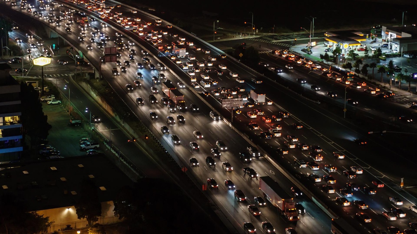
Fire engines, ambulances, and buses first!
Big Data, artificial intelligence (AI) and 5G are making our cities smart: Intelligent traffic management systems are efficiently orchestrating urban traffic. The result? An end to columns of cars snaking their way through the streets at a snail’s pace. Buses, ambulances, and fire engines quickly reach their destination, despite the rush hour. People and the environment are benefiting from that – including those driving commercial vehicles of all kinds as they get around the city.
Cities are growing worldwide, and the numbers living in them are steadily increasing too. By 2030, according to estimates by the United Nations, around 60 percent of the world’s population will live in urban areas. In 2021 it was 4.5 billion people, or 57 percent of the roughly eight billion people living on this earth. Currently, there are 34 megacities, each with over ten million inhabitants. All of them are on the move in the area where they live and work - by car, on foot, or using micro-vehicles; they are looking for parking spaces, they use municipal transport, they have goods delivered, or they buy things from shops that need to be supplied with goods.
The urban mobility landscape is becoming more complex, with more and more actors moving around the streets. If our cities are to remain clean and places worth living in, the authorities need to direct the traffic in completely different ways to how they have done in the past. The latest technologies are helping to avoid traffic jams and emissions and to increase road safety.
Was ist Verkehrsmanagement?

A green wave using adaptive traffic management
The buzzwords here are: Big Data, artificial intelligence, car2X and connectivity. Companies like Yunex Traffic, Swarco and Kapsch have developed smart traffic management systems that read off traffic and environmental data. The data is used for traffic management to reduce travel time and emissions of CO2 and NO2. The data is anonymized and then used to manage the traffic.
Intelligent Traffic Systems (ITS) recognize the various vehicle classes, along with pedestrians and cyclists – and adapt the traffic management to the special mobility needs of the city. These vary depending on the location, the situation, the vehicles, the time of day, the weather, and the environmental pollution. Thus, for instance, car traffic can be prioritized during the rush hour. At school times as lessons end and during pick-up times from daycare centers, priority can be given instead to pedestrian traffic. Passenger transport vehicles, police vehicles, ambulances or delivery vehicles can be prioritized as needed. Similarly, private vehicles can rapidly be guided out of a particularly critical area, or vehicles diverted before they run into a traffic jam.
The complete data flows to a control center that manages all the urban traffic. For example, it also programs dynamic road signs that provide drivers with recommendations as to speed and which roads to use. If you follow these recommendations, you ride the city on a ‘green wave’ and avoid high-emission stop and go driving.
Interplay of hardware and software
While it’s true that the urban infrastructure needs upgrading to install an ITS, existing infrastructure elements can be expanded and integrated into the system. Wiesbaden is a good example of how that works: With its Digi-V project, the capital of Hesse is looking to no longer be one of the 70 German cities which regularly exceed NOx limits – and to avoid bans on driving in the city center.
All traffic light systems on the major road network are being equipped with control, camera and sensor technology. Thus 227 lights were modified, and 50 environmental sensors or weather sensors and around 400 cameras deployed. They differentiate between road-users such as trucks, cars, buses, cycles, and pedestrians. They do not capture faces or registration numbers.
Sensors measure pollutants such as NOx and particulates in the air. These, and additional weather data, are linked with the information on traffic density and traffic types, and evaluated. Via dynamic road signs, road-users receive recommendations on routes and speed. The traffic is orchestrated in the way that is required, given the volume of traffic on the road and the environmental information – for instance, passenger buses are given priority so that they can reach their destination more quickly. For Wiesbaden residents, it then makes sense to leave their car at home.
Das Projekt DIGI-V digitalisiert den Verkehr in der hessischen Landeshauptstadt Wiesbaden und soll helfen, Emissionen zu vermeiden.
Was ist DIGI-V?
Roadside units communicate with on-board units
However, vehicles can also communicate directly with the urban infrastructure: Intelligent signal switches, adaptable road signs and even smart car parks can exchange data with road-users via radio technologies such as 5G and via a radio module, a roadside unit (RSU). RSUs can be installed in many locations – on bridges or traffic lights, for example. They send and receive signals.
Using on-board units (OBU) in vehicles, road-users can be warned in real time about speed limits or traffic jams, for example. Vehicles with suitable OBUs use these to report their current location, direction of travel and speed. The RSU receives the information and forwards it to the central traffic management system. In turn, this independently controls green and red phases on lights, or digital traffic signals. Ambulances and fire engines, for example, are able to negotiate junctions smoothly, because the infrastructure recognizes them.
Traffic management in the road surface
Managing the traffic using smart technologies can even be achieved via the road surface: The start-up Integrated Roadways, based in Kansas City (USA), has developed a smart pavement that recognizes vehicles driving over it. Instead of asphalt, the roads are laid out using prefabricated concrete slabs with sensors integrated into them. They record the vehicles and signal their location and speed.
The smart road surface is no longer just a vision: In 2018, Denver became the first city in the USA to use the “smart pavement” from Integrated Roadways, installing four of these smart slabs. In fall 2022, the company is launching a USD 250 million pilot program in Lenexa, in the state of Kansas: At five junctions in the city center, concrete sections of road are being installed that are equipped with digital technology and glass fiber connections, to record traffic data using sensors. The surface enables Wi-Fi access, 5G, wireless charging of electric vehicles and more, using antennae in the expansion connectors, along with Edge services and Cloud access.
Smart City is the concept of the future
In Germany, this still lies some way off in the future. Few cities and local authorities presently have the necessary level of digitalization. In many cases, too, they lack comprehensive data on the local transport offering and are not able to comprehensively evaluate the actual transport demand or the quality of the traffic flow in their area.
For that reason, the Board of Academic Advisors to the Federal Minister for Transport and Digital Infrastructure is recommending support for standardization of data in the transport sector. In addition, it is recommending that consistent rules be developed Germany-wide to define the responsibility for providing planning data. Beyond this, the Federal state and the regional States should conclude arrangements with the providers of mobile radio data and floating car data to allow the cities and regions to have simple access to demand data and traffic flow data.
All that could contribute to enabling the two megatrends of the 21st century, urbanization and big data, to come together in the concept of the Smart City. If the new technologies are correctly managed and used, then Big Data, artificial intelligence and automation can make our urban mobility more sustainable. How we design our cities – including digitalization – will be decisive for the onward path in greenhouse gas emissions and climate protection.